Der bulgarische Grafikdesigner Yanko Tsvetkov visualisiert nationale und historische Stereotype in unterhaltsamer Form. Wir beleuchten seine Arbeit und sprachen mit ihm über seinen neu erschienenen, zweiten Atlas der Vorurteile.
von Frank
Info-Grafiken erfreuen sich beim Publikum großer Beliebtheit: Vom Internet-Phänomen bei Tumblr und Co. haben sie es längst in die Buchläden geschafft. Freilich geht es dabei eher um Unterhaltung als um bierernste wissenschaftliche Statistiken. Dass solche Grafik-Kunst aber durchaus ernsthafte Themen behandeln kann, hat der bulgarische Grafikdesigner und Autor Yanko Tsvetkov mit seinem Projekt Mapping Stereotypes (im Deutschen: Atlas der Vorurteile) gezeigt.
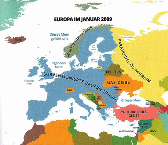
Tsvetkov, 1976 in Varna am Schwarzen Meer geboren, veröffentlichte seine erste satirische Landkarte 2009 im Internet. Zu diesem Zeitpunkt hatte er unter seinem Spitznamen „alphadesigner“ bereits eine eigene Website gestartet, nachdem er erst eine Ausbildung zum Kameramann begonnen, sich dann aber von der Filmkunst abgewandt und sich in Fotografie, Illustration, Graphikdesign und Schreiben verliebt hatte. Die erste Karte entsprang zunächst der spontanen Idee, nationale und historische Klischees zu visualisieren. Bald stieß sie auf ein großes Echo im Web, weitere „Stereotyp-Kartierungen“ folgten und mündeten 2013 erstmals in eine Publikation in Buchform. Zu diesem Zeitpunkt hatte Tsvetkovs Projekt bereits ein großes Medienecho hervorgerufen: Die britischen Zeitungen Guardian und Daily Telegraph berichteten, es gab Beiträge in russischen und italienischen Medien; auch die Süddeutsche Zeitung und der Spiegel wurden auf den „Kartographen“ aufmerksam.
Kindlicher Spieltrieb. Oder: Warum ausgerechnet Atlanten?
Tsvetkov, der mittlerweile mehrere Kontinente und zahllose Länder bereist hat, begann bereits als Kind – mangels anderer bunter Bücher – die Atlanten seiner Tante zu entdecken: „Ich erinnere mich, dass ich gewöhnlich einen Atlas nahm, eine Seite daraus gegen die Scheibe presste, einen Bogen Papier darüber legte, sodass ich hindurchsehen konnte und dann die Umrisse der Länder nachzeichnete. Es dauerte nicht lange und ich begann damit, die Grenzen zu verschieben“, erinnert er sich in seinem ersten Buch (2013 erschienen bei Knesebeck). In diesem widmet er sich im Wesentlichen der Visualisierung Europas und der USA. Dabei nimmt er natürlich u. a. das fast schon sprichwörtliche Unwissen der Amerikaner über andere Länder auf die Schippe. Aber Tsvetkov verarbeitete auch zeitgenössische politische Entwicklungen, etwa den Arabischen Frühling. In Essays zu dem Projekt und zu einzelnen Karten bietet das Buch kurzweilig und unterhaltsam die historischen Hintergründe und oftmals ausführliche Erläuterungen zu den Karten. Der Gehalt von Tsvetkovs Ausführungen wird zwar merklich schwächer, wenn er sich ins Philosophische verliert; auch fallen historische Zusammenhänge teils sehr holzschnittartig aus – doch sein Atlas der Vorurteile ist schließlich weder ein Geschichts- noch ein Lehrbuch!
Tsvetkov stellt in seinem ersten Buch auch die zentrale Frage: Können wir uns überhaupt völlig von Vorurteilen befreien? „Man könnte versucht sein, sie als Unvermeidlichkeit zu akzeptieren, als ein dem menschlichen Wesen inhärenter Mangel. Allerdings ist die Liste dessen, was man einst als unvermeidlich angesehen, später aber als Unfug erkannt hat, länger als unsere DNA.“ Stattdessen solle jeder lieber die grauen Zellen anstrengen und selbst Informationen und Eindrücke sammeln: „In einer global vernetzten Gesellschaft, in der Informationen schneller als Gedanken strömen, können sich Vorurteile als intellektuelle Faulheit entpuppen.“
Sein zweiter Atlas der Vorurteile erscheint dieser Tage auf Deutsch. Im Interview verrät er uns, was den neuen Band ausmacht und welche Rolle die europäische Krise als Katalysator seiner Ideen spielt:
unique: Mr. Tsetkov, what are the main innovations or changes in your new book compared to the first one?
Yanko Tsetkov: This time I tried to shift the focus to important themes about our past. One of the main maps is dedicated to the world according to Christopher Columbus and the way he “discovered” America. The chapter to which it belongs is the backbone of the book and is titled “Chasing the Horizon”: It’s about human curiosity and the limits of our imagination. There is also a culinary horror map of Europe, which offers a collection of strange traditional food across the continent. But my favorite one depicts the world according to Facebook users. It’s a physical, not a political map, and that was a challenge for me because it’s much more visually complex.How do you “investigate” all these stereotypes, especially from other countries or other eras, e.g. the Middle Ages? What are the foundations or “data” for your maps?
Some people are tempted to look at my maps as scientific info graphics. I always emphasize that they are a work of satire and as such, they are not a product of a systematic research. I follow the news, I read a lot of history, and I communicate with a lot of people all over the globe on a daily basis. However, none of these activities is specifically dedicated to stereotype research. I don’t read the latest news expecting I will get an idea about a map, I am just interested what happens on the planet. If something comes to my mind, I try to develop it naturally and without any rushing.Do your own personal prejudices come into play as some kind of inspiration, or do you try to leave them aside?
They come into play all the time. My overall interest in the theme was inspired by my own limitations and my struggle to open myself up to new cultures. It’s an ongoing fight with a constant supply of new ideas.From the texts in your first book, I got the impression that you are traveling a lot. How important is this as part of your inspiration or “data collecting”?
Traveling is important but not essential. I know people who travel a lot but rarely take the opportunity to study the new environments they encounter. What makes “data collection” possible is the ability to communicate with people. It may happen face to face, via telephone, chat, social networks… Of course, once you collect the raw data, you have to bring it to life, to put it in a vital context. This is where traveling helps a lot. But it can only happen if you have done your homework beforehand. Otherwise it’s simply tourism.After your first book, some people criticized your Mapping Stereotypes project as a way of earning money simply by offending people and nations. Where there any changes in this criticism over the time?
This happened even before I wrote the book, at the time when Mapping Stereotypes was just a collection of maps presented on my website. I have a strict policy of not yielding to cynicism. Those who are arrogant enough to imagine I could do something like that will never believe any assurance of the contrary, so it’s just a waste of time to pay attention to them.The crisis in Europe seems to play a mayor role for your work on stereotypes – as a source of inspiration for you. What’s your look on the growing tendencies of re-nationalization in Europe?
I think the contemporary nationalist wave in Europe is just misguided desperation caused by the financial crisis. It becomes easier to spot this if we compare today’s situation to what was going on 100 years ago, when nationalism reached its apogee as an ideology. There aren’t many alternatives to European integration, especially for the countries which are already in the European Union. Even the British conservatives don’t want to pull out of the EU completely and use the threat of leaving only in carefully calculated messages aimed at their local electorate. Nationalism gets a hit every time RyanAir lowers its plane ticket prices. There is no going back to it. At least I hope so.At the end of your first book, you offered a satiric prediction for Europe in the year 2022, five years after a major split would have occurred and a “Merkel-Reich” was formed. How would your prediction look today, in the year of the European election?
I wouldn’t change it very much because the things I satirized at the time are still present. Some even turned to nightmares, like Russia’s renewed pressure on Eastern Europe. I hope the map doesn’t become a reality!Thank you very much, Mr. Tsetkov.
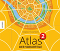 Yanko Tsvetkov: Atlas der Vorurteile 2
Knesebeck-Verlag 2014
80 Seiten, durchgehend farbig illustriert
16,95 €
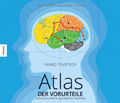 Yanko Tsvetkov: Atlas der Vorurteile
Knesebeck-Verlag 2013
80 Seiten, durchgehend farbig illustriert
16,95 €
Schreibe einen Kommentar